Historical Sketch of Charlotte Court House, Virginia
By Judge Robert F. Hutcheson
Source: Charlotte County History
An Interesting Sketch Containing Historical Data of Charlotte County
(Editor's Note: This is one of the first of a series of articles that will be published in The Charlotte Gazette, dealing with the history of some part or episode in the County. The articles should prove both interesting and instructive and should be read by everyone interested in our County. Other articles will appear in early issues.)
On December 7,1923 Judge Robert F. Hutcheson gave an addressed titled “Historical Sketch of Charlotte Court House” to the Charlotte County Branch of the Association for the Preservation of Virginia Antiquities (A.P.V.A.). The talk was published by the Farmville Herald Feb. 8, 1929.
Submitted By: Brady Fitts
The search for the beginning of Charlotte Courthouse takes us back to the French & Indian War. After the disastrous defeat of General Braddock and his British regulars at Fort Duquesne in 1755, there was grave apprehension in Virginia that the Indians, incited by the French and encouraged by victory, would descend upon the settlers in the frontier counties bent upon massacre and pillage, Governor Dinwiddie was compelled to rely upon the colonial militia for protection against this danger, especially that of the counties near the frontier, among which was Lunenburg. He inaugurated a vigorous campaign of defense, which included the building and garrisoning of a line of forts in Augusta, Bedford, Halifax, and perhaps other counties in the western and southwestern part of the State. In these efforts he received valuable assistance from Colonel Clement Read, of Bushy Forest, who asked as one of his commissary officers, and was entrusted with the duty of seeing that the forts and the militia companies in the field were supplied with arms, ammunitions and provisions.1 Upon recommendation of Colonial Read, the Governor authorized the building of a magazine, or storage depot, for these supplies, with the idea, we may conjecture, of placing them far enough back from the area of actual hostilities to make them reasonably safe, and yet of having them at a point more accessible to the forts than far off Williamsburg.2 This magazine was located by Colonel Read where Charlotte Courthouse now stands. The exact spot is not definitely known, but references to it in deeds and court order books indicate that it probably stood on the present Courthouse Square. It was built in 1756. The first of the various names by which the place has been known was therefore “The Magazine,” or, “The place where the Magazine stands.”3 It is so called in a number of old deeds and court orders, and in one Act of the House of Burgesses, to be presently mentioned.
The entire present site of the village was undoubtedly covered with forest at that time, and even sixty years later there were many wood lots inside the present corporate limits. If we give a little reign to our imaginations, we can picture the sudden change from wilderness solitude to busy activity as workmen felled the trees and constructed the fort, and a little later wagon began to roll in from Williamsburg, bringing up powder and rifles, and others to roll out towards the West, laden with supplies for the forts. It may be, too, that the Lunenburg militiamen, whose names are found in the seventh volume of Henning’s Statutes, mustered here before marching away for actual duty in the field. At any rate, something suggested the idea of building a town here, and this brings us to our second name, which was.
DALSTONBURGH
The original patent for the land on which the village stands appears to have been issued to John Pleasants, of Henrico,4 who sold a part of it to Clement Read, and afterwards disposed of all interest to Clement Read, and his son, Thomas. After the death of Clement Read, the Elder, in 1763, Clement Read, Junior, and Thomas Read conveyed it to their mother, Mary Read; she owned it until her death in 1780, and gave it back by her will to Thomas, who kept it until his death in 1817. It therefore remained in the Read family, as their private town, for over fifty years after the idea of establishing a settlement here was first conceived. But to get back to Dalstonburgh: in February, 1759, in the 32nd year of George III., the House of Burgesses enacted a statue which reads as follows:5
“Whereas, the erecting towns on the frontiers of this Colony may be of great benefit to the Inhabitants, by encouraging many of them to settle together, which will enable them the better to defend their lives and properties on any sudden Incursion of the enemy; and, Whereas, It has been represented to this General Assembly that one hundred acres of land belonging to Clement Read and John Pleasant, in the County of Lunenburg, where the Public Magazine was lately erected, are laid off into lots and streets for a town, and that many persons have subscribed for such lots;
Be it Therefore Enacted, by the Lieutenant Governor, Council and Burgesses of this present Assembly, and it is hereby enacted by the authority of the same - - That the land so laid off in the County of Lunenburg, at the place where the Public Magazine was lately erected, shall be and is hereby established a town, and shall be galled and known by the name of Dalstonburgh.”
In another clause, Clement Read, Thomas Boulden, Thomas Bedford, Paul Carrington, William Caldwell, and Clement Read, junior, were named as trustees for the town, with authority to make orders, rules and regulations for the orderly building of houses, and to settle disputes concerning the boundaries of lots. It was also made unlawful for any person to erect or build any wooden chimney in said town.
The subscribers for the lots referred to in the Act evidently did not become purchasers, as there are no deeds of record from the Reads for any lots at the time. Some buildings were erected – just how many it is impossible to say. One of them was a tavern, for the County Court made the following order in May 1765: “ordered, that the Ordinary Keeper of this Courthouse provide small beer on court days for the court.” The Court was required by law to regulate the charges of ordinaries for entertainment and refreshment, and the schedule for 1765 was as follows:
| Entertainment and Refreshment | L | s. | d. |
| “West India Rum by the Gallon | 0 | 10 | 0 |
| Madeira Wine by the Quart | 0 | 2 | 6 |
| Peach Brandy by the Gallon | 0 | 8 | 0 |
| Apple Brandy by the Gallon | 0 | 6 | 0 |
| Good Virginia Cyder by the Quart | 0 | 0 | 4 |
| New England Rum by the Gallon | 0 | 6 | 0 |
| Bristol Cyder by the Quart | 0 | 1 | 3 |
| Strong Beer by the Quart | 0 | 1 | 3 |
| A dinner | 0 | 1 | 0 |
| A breakfast | 0 | 0 | 8 |
| Corn by the Gallon | 0 | 0 | 7 1/2 |
| Oats by the Gallon | 0 | 0 | 4 |
| Punch, with white sugar & good Rum by the Quart | 0 | 1 | 3 |
| French Brandy by the Gallon | 0 | 20 | 0 |
| Portugal French White Wine by the Quart | 0 | 5 | 0 |
| Virginia Strong Beer by the Quart | 0 | 0 | 6 |
| Lodging with clean sheets, one night | 0 | 0 | 6 |
| Pasturage for a Horse, 24 hours | 0 | 0 | 6 |
| Stablage, Fodder & Provender for a Horse, one night | 0 | 0 | 6 |
"And so proportionately for a greater or less quantity.”
The records do not show how long, or how generally, the name Dalstonburgh was used. In addition to the Act quoted above, it is found only in the deed from Thomas Read and Clement Read to Mary Read in 1765, where the description is, “70 acres of land lying in the town of Dalstonburgh, . . . . .to include the new Ordinary House, Courthouse, Prison, and all houses, edifices, buildings, yards, etc.”6
In Fry and Jefferson’s map, appended to Jefferson’s Notes on Virginia, 1782, the name “Read” appears about where the village is now located, but this may have been intended to mark the family seat, and not as the name of the town.7 Sometime in this period the name was changed, in honor of Madam Read, to.
MARYSVILLE
Mary Read was the wife Clement Road, the Elder. She is said to have been the only daughter of William Hill, second son of the Marquis of Lands downs, and an officer in the British Navy, who had settled in Virginia in Brunswick County. She was married in 1730 and came with her husband to what is now Charlotte in 1733. After Colonel Read’s death, she took charge of Bushy Forest and managed it with great ability until her death in 1780. She is buried somewhere on that estate by the side of her distinguished husband.8 She was an accomplished woman, endowed with great force of character. Long before the days of suffrage and propaganda for equal rights, she played a man’s part in the hardships of frontier life, and so impressed herself on her generation that her memory still lingers after a hundred and fifty years around the scenes where she lived.
Little is known of the history of the town between 1765 and 1817, a long period in which occurred the Revolution, the establishment of the Federal Government, and the War of 1812. A company of Lafayette’s French soldiers was quartered in the village during the Revolution, and a number of interesting stories about them may be found in “The Old Trunk.”9 The account from one of Washington’s Dairies, of his breakfasting here in 1791, was contained in a recent issue of the Charlotte Gazette.
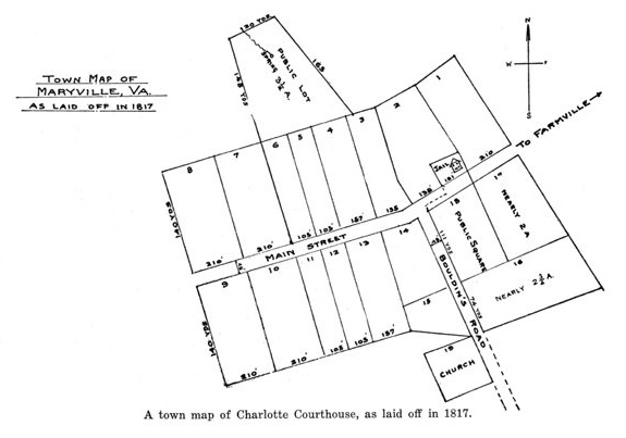
Colonial Thomas Read died in 1817. By his will he devised his whole estate to his only child, Margaret, but she died before him and his property passed to all the descendants of his father, Clement Read. A suit was brought to sell his numerous tracts of land for division among these heirs. The complete record of the case (John vs. Read et al) is contained in the Book of Land Causes in our Clerk’s Office, and constitutes a valuable source of information, not only as a record of the names of the descendants of Clement Read, but as the common title source of all the real estate in the village. The Commissioners appointed to sell the lands decided, with the approved of the court, to divide his Court House Tract of 653 acres into “Town Lots” and “Wood Lots” and to sell them at auction, which was done. The town proper, as then subdivided and plotted, extended along Main Street on both sides from a point a little below the present hotel to Mr. S. C. Daniel’s gate, and on the Drakes Branch road (then known as Bouldin’s Road), only to the Presbyterian Church. This space was divided into 19 lots, varying in size from one to two acres. The “Public Lot,” back of the town containing 31/2 acres around the Tanyard Spring, was not sold, but was dedicated to the use of all owners of lots in the town, in common, and it so remains to this day. The land outside this town site proper, being that upon which most of the residences in the village are now situated, was sold as “Wood Lots,” containing from 30 to 75 acres each. A copy of this map of the town as it was laid off in 1817, with list of the names of the purchasers of town lots and of wood lots, is appended for the information of those who may be interested.
The ten or fifteen years following 1817 were probably the greatest boom period in the history of the town. Many new residences, churches and business houses were erected, some of them very substantial brick structures which are still standing. According to Martin’s Gazetteer of Virginia, in 1836 the town of Marysville contained 475 people, and had the following business establishments:
- 5 Mercantile Stores
- 2 Well kept Taverns
- 3 Boot & Shoe Factories
- 4 Wagon-makers Shops, each employing 8 to 10 hands
- 1 Carriage Maker
- 2 Tailor Shops, each employing a number of hands
- 1 Tanner
- 3 Saddlers
- 3 Blacksmiths
- 1 Cabinet Maker
- Several House Carpenters and Bricklayers
In 1852 the Marysville Plank Road Company was charterer.10 The incorporators named in the charter were George W. Read, Wyatt Cardwell, William t. Scott, Thomas E. Watkins, and Richard I. Gaines; its purpose was “for constructing a plank road from Charlotte Court House to the Richmond & Danville Railroad at some point between Keysville and Overby’s Store.” The selection of this point doubtless determined the location of the town of Drakes Branch. The road established was a toll road, the toll house being at the intersection of the plank road with the Keysville and Overbey’s Store road, and the depot in this village was the old square frame building next to Mrs. Thornton’s, which is still standing and retains its name of the Freight House. The plank road was considered a marvelous improvement in methods of transportation - - - while it was still new. The tradition is that it became the fad for the young men of the trip in the shortest time. Among these enthusiasts was young Mr. Terhune, pastor of Village Church; he had a very fine pair of horses, but laid himself open to some criticism from the more sober members of his congregation who thought he had a little too much sporting blood for a parson. The road lasted less than ten years and was torn up and abandoned in 1860, the idea having proved impracticable.
SMITHVILLE
In 1874 it was decided to become an incorporated town in order to enjoy the benefits of a town government and do something in the way of civic improvement, and at the same time the name was changed from Marysville to Smithville.11 This was done in honor of the Smith family which had been long and prominently connected with the history of the town. William Smith was one of the original purchasers of lots in the town in 1817; he built Smith’s Tavern and conducted it for thirty years, during which it became a famous hostelry, and he was connected in numerous ways with the business, social and religious life of the community. His son, William A. Smith, and his grandson, William Smith, were Clerks of the Circuit Court for a long period, and other members of the family lived in the village and had a part in its life. All three William Smiths, as well as others of their family, are buried in the private cemetery on the old Smith’s Tavern Lot, which lies back of the present Caldonia Hotel.
CHARLOTTE COURT HOUSE
The name Smithville was retained until 1901 when it was again changed by Act of the Legislature to Charlotte Court House.12 Through all the years, no matter what it might choose to call itself, it had always been the “Cote House” to the people of the county, and the final judgment of its own citizens on the question of names approved the choice. It is said that Charlotte Courthouse and Washington Courthouse, Ohio, are the only two county seats in the United States which are permitted by the Post Office Department to use the word “Courthouse” as a part of their official names.
The following notes on the history of the older buildings in the town have been collected chiefly from the Clerk’s Office records.
Public Buildings
There have been three Courthouse buildings. The first was a frame structure, 30 to 32 feet, built by Clement Read, junior, and Mary Read when the County was organized in 1765. It was burned in 1784. The first order entered by the Court at its February Term of that year reads as follows: “The Court met at the usual place of holding courts, and the Courthouse being burned down by some evil disposed person or persons unknown, in order to delay the ordinary course of justice, the Court there upon unanimously agreed to adjourn to the Merchant’s house within the limits of the prison rules of the said County, and then and there to proceed to business, and accordingly adjourned to the said house, and proceeded to the business of the County.”14
The second building was completed in 1785 under the supervision of a committee composed of “Samuel White, John Daniel, Francis Scott, Little Joe Morton, Edmund Read and Jacob Morton, Gentlemen.” It was also a frame building, but larger than the first, its dimensions being 32 by 24, with jury rooms on each side, 12 by 14 feet, all under one roof, outside brick chimneys and a portico in front, to be painted, says the Court’s order, with red roof, white body, and blue doors and windows.13 It was just after the Revolution, and the Court was nothing if not patriotic. This building stood until 1823, when it was sold at auction and purchased by William Smith and Winslow Robinson. The tradition is that the old stable which stood on the Smith’s Tavern lot until recent years was a part of the old Courthouse, or at any rate, built from its timbers, and this is doubtless a fact.
The present building was erected in 1823 under the direction of a building committee composed of Clement Carrington, Isaac Read, Wm. M. Watkins, Joseph Wyatt, Henry A. Watkins, John Morton, Jr., and Henry Carrington. It has always been stated as a fact in the village that this committee sent some of the members to Monticello to consult with the aged Thomas Jefferson about plans for the building, and there is no reason to doubt the story.
The present jail was built in 1828. There were seven prior to it, some of which, if not all, stood just back of the present site of Smith & Co.’s Store, a small corner on that side of the road being a part of the public square until 1828.
Churches
The Presbyterian is the oldest of the three churches in the town. It was organized in 1825 largely from the membership of old Cub Creek, but it had been a preaching point for the ministers of Briery and Cub Creek, under the name of the “Village Congregation” for a long time previous to its organization, and a building known as the Brick Church had been built, back in the days when all the land in the village belonged to the Reads. There is no deed to it on record. It was probably given by the Read family as a Meeting House for the Presbyterian before there was any provision in the law permitting Dissenters to hold land for church purposes. The old Brick Church was destroyed by fire and the church lot, and does not belong to the Presbyterians exclusively. It was conveyed in 1840 by Winslow Robinson to Dr. Wm. H. Patillo and Leven B. Hagerman in trust that they and their successors, to be appointed by the County Court, should hold it for the sole and exclusive purpose of a burying ground for the village forever.14
The next oldest church is Mount Tirzah Baptist. The lot was conveyed in 1836 by Watt Cardwell to John Roach, Sr., James Morrison, Archibald A. Davidson, Josiah Dabbs, John T. Lovelace, Francis Caldwell and Robert Shackleton as trustees, but this deed also states that an older church had stood on the same lot and had been burned. That the donor believed in being liberal, but not too liberal, is evidenced by the following clause in the deed: “And in farther trust and confidence that the above trustees may invite pious, holy and orthodox ministers of other denominations to preach in the said church; but in such invitation the trustees are to remember that the Bible says there are six things the Lord hates and one of them is he that sows the seeds of discord among brethren; therefore in such invitation they shall exclude all men who may attempt to sow the seeds of discord amongst the members of the Baptist denomination.16
The Methodist Church lot was conveyed in 1841 by William Smith and Josiah Dabbs to Lewis Skidmore, Robert E. Bouldin, Elisha Hundley, Henry T. Redd, Henry J. Venable, Thomas Wilbon, James Terrill, Geo. I. Roberts and Henderson Handley in trust “that they shall build thereon a House or Place of Worship for the use of the members of the Methodist Worship for the use of the members of the Methodist Episcopal Church in the U. S. A.”17
Grace Episcopal Church formerly stood just back of the present site of Dunnavant’s Garage. The lot was given by Henry Carrington in 1858, and the church built on it soon afterwards. In 1879 it was moved to Drakes Branch, and is still in use there.18
Taverns
What the town was laid off in 1817, what was then known as the Old Tavern stood on the lot now occupied by Mr. Allen B. Williams, Jr., commonly known as the Downing Lot. It is very probable that this was the site of the original Ordinary from which John Tankersley furnished small beer to the Court in 1765, and where George Washington had his breakfast in 1791. The name of the proprietor in 1791 was John Timberlake. All the town lots were sold in 1817 subject to a covenant that the owner would open no new tavern for five years in competition with the Widow Rutherford, who had a lease on the Old Tavern.
William Smith purchased his Tavern lot in 1820 and probably erected the building soon afterwards. It was a long, two-story, frame building, with a wide, piazza extending across the entire front, supported by large brick columns. It stood until 1899, when it was destroyed by fire, and the Caledonia Hotel, a much smaller building was afterwards built on the site by Mrs. Isabella Donald.
The Brick Tavern, across the street from Smith’s Tavern, was build by Wm. M. Watkins about the same time as the Courthouse, and sold by him in 1832 to Wyatt Cardwell, who was its proprietor until just before the Civil War. He and William Smith were rival landlords for many years, but for a brief period in the fifties, Cardwell owned both establishments.
Stores
The brick store building with tall white columns which is now owned by Mr. B. F. Jones has long been one of the landmarks of the town. Some (not all) of the firms which have engaged in the mercantile business in this store are Eggleston, Thorton & Co.; Daniel & Tucker; Joel W. & J. P. Marshall; and Atkins and Marshall. The lot was purchased in 1819 by Henry A Watkins, who owned it until his death in 1849. He was a son of Joel Watkins, of Woodfork, and served with his brother, Wm. M. Watkins, on the committee which built the Courthouse in 1828. It seems very likely that he built his store about the same time, and the style of the architecture strengthens the supposition.
A store was run on the opposite corner, where the Bank now stands, for more than a hundred years. Some of the firms which have done business here have been J. H. Ingram; Ingram & Thompson; N. E. Flornoy; James Scott; Scott, Booker & Green; Dickinson & Barksdale; and Archibald Vaughan. It belonged to James Scott and his heirs from 1853 to 1886, and it is for this reason that the voting precinct on this corner is still known as Scott’s Store Precinct. The last store building was burned in 19XX and the bank erected in its place.
Prominent Citizens
So many worthy and substantial people have lived in the town during its long history that it is perilous to single out any of them as prominent without making invidious distinctions, but we will conclude with a brief mention of a few who became well known outside the limits of the county in past years.
Colonel Thomas Read never lived in the town, so far as is known, but he was its Lord Proprietor for so many years that he deserves mention. His home was at Ingleside. He was Clerk of the County from 1766 until his death in 1817; was its County Lieutenant during the Revolution; was a member of the Virginia Convention of 1776, which framed the first Constitution of Virginia and the Bill of Rights, and also of the Convention of 1788, which adopted the Federal Constitution. In his public duties he was intimately associated with Washington, Jefferson, Henry, Madison, Monroe and Marshall, and shared with them the labor of framing and establishing the government of the State and Nation.
James W. Bouldin, who was living on the Smith’s Tavern lot when the town was laid off, was a lawyer of note and a Member of Congress from 1834 to 1839.
His nephew, Wood Bouldin, who became a Judge of the Supreme Court of Appeals of Virginia, and was also a member of the Virginia Secession Convention, began his practice of law at Charlotte Courthouse in 1833, and lived in the old Manse, which he owned at the time.
Mrs. Mary Virginia Terhune, the author, better known as Marion Harland, lived in the same house from 1855 to 1859, while her husband was pastor of Village Church, and wrote several of her books here.
Rev. Nash Legrand, a Presbyterian minister famous among the early preachers of that denomination for his eloquence and evangelistic zeal, lived for a time in his later years in the grove opposite the Presbyterian Church,, which was the dower property of his hardly less distinguished wife, Paulina, who was born a Cabell, married first Colonel Edmund Read, and the Nash Legrand.
Judge Hunter H. Marshall practiced law here, and built and lived in the house now occupied by Mr. Vanvolkenburg. He was a Judge of the Circuit Court, and afterwards moved to Richmond and became one of the leaders of that bar, and counsel for the Richmond & Danville Railroad.
William Wirt Henry, a grandson of Patrick Henry, and a distinguished lawyer, historian and writer, also practiced law here and built the house which Mr. Gordon Smith now owns.
And lastly, David Q. Eggleston, a member of the Virginia Senate, and of the Constitution Convention of 1902, and Secretary of the Commonwealth from 1902 to 1909, was born in this village in 1857, and made it his home until his death in 1909.
List of Purchasers of Town Lots in Maryville in 1817
| Lot No. 1 | James W. Bouldin | $910.00 |
| Lot No. 2 | John Morton & Co. | $2,610.00 |
| Lot No. 3 | James P. Marshall | $1,100.00 |
| Lot No. 4 | Williamson Price | $3,600.00 |
| Lot No. 5 | William Smith | $700.00 |
| Lot No. 6 | William Smith | $380.00 |
| Lot No. 7 | William White | $855.00 |
| Lot No. 8 | John Johnson | $255.00 |
| Lot No. 9 | Christopher Hunt & Wm. L. Morton | $550.00 |
| Lot No. 10 | Christopher Hunt & Wm. Morton | $350.00 |
| Lot No. 11 | Jno. Marshall & Henry W. Tucker | $900.00 |
| Lot No. 12 | James P. Marshall | $1,000.00 |
| Lot No. 13 | Williamson Price | $810.00 |
| Lot No. 14 | Isaac Read | $1,450.00 |
| Lot No. 15 | Isaac Read | $100.00 |
| Lot No. 16 | John Robinson | $560.00 |
| Lot No. 17 | Wm. M. Watkins | $400.00 |
| Lot No. 18 | Public Square | not sold |
| Lot No. 19 | Church Lot | not sold |
The prices paid for these lots give some indication of where buildings were probably located in 1817. Interpreting the map in this light, we may conjecture that: A small dwelling was on Lot No. 1, now the Caledonia Hotel, which was occupied by Jas. W. Bouldin before the sale and bought at sale by him.
A store, on No. 2, which extended from the Hotel Lot to Jones’ Store.
A store was on No. 3, which extended from Jones’ Store to Mrs. Atkins, but not the present brick building.
The Old Tavern occupied No. 4 and No. 13 on the opposite side of the street was used in connection with it, there being a brick lumber yard and perhaps other building on this site.
Buildings stood on the lots occupied now by Mr. Ramsey and Mrs. Thornton.
There was a store on the corner now occupied by the Bank. The prices would not indicate that there were any other buildings of consequence.
List of Purchasers of Wood Lots Just Outside Maryville 1817
- No. 1 – Wm. M. Watkins, 29 acres, Gordon Smith’s and Villeview.
- No 2 – John Morton & Co., 32 acres, S. c. Daniels and back of the Tanyard Spring
- No. 3 – Wm. L. Morton, 33 ½ acres from Caledonia Hotel to Mrs. Franke’s place
- No. 4 & 5 – Stephen Davis, 29 A. & 38 A. in folk between Farmville Road and old Keysville Road
- No. 6 & 7 – Clement Carrington, 116 A. from colored churches across to and including Bon Air
- No. 8 & 9 – Isaac Read, 136 acres, from Bon Air to Baptist Church lot
- No. 10 – Wm. M. Watkins, 32 acres, from Baptist Church to Brick Hotel
- No. 11 – Paulina Legrande, 36 ½ acres, opposite Presbyterian Church
- No. 12 – John Robinson, 28 acres, back of Presbyterian Church and at Norvells
- No. 13 – James P. Marshall, 39 acres, B. P. Eggleston place
- No. 14 – William Smith, 35 ½ acres, below B. P. Eggleston house
- No. 15 – Christopher Hunt, 33 acres, Manse Lot to Watkin’s
- No. 16 – John Morton, 31 ½ acres, Watkins to fork of road
Reference:
- Bell: “The Old Free State” Vol. 1, pp. 180-187
- Dinwiddie Paper, Vol. II, pp. 485-6
- Charlotte County Record: Deed Bk. 1. Pp. 108-110; County Court Order Bk. 1, p. 5
- Lunenburg Records: Deed Bk. 3, p. 3, and Deed Bk. 10, p. 85
- Henning’s Statutes - Laws of Virginia, February 1759—Chap. XXIII, pp. 304 – 305 - “An Act for establishing several towns therein mentioned” para. II
- Charlotte County Records, Deed Bk. 1, p.27
- The Old Free State, Vol. I, p. 149
- Powhatan Bouldin, “The Old Trunk,” pp.5, 50 and 51
- Powhatan Bouldin, “The Old Trunk,” pp.38 – 40
- Acts of Assembly 1852, p. 133
- Acts of Assembly, Session 1873-4
- An Act to change the name of the Town of Smithfield, Approved Dec. 21, 1901
- Charlotte County Order Bk. 5, p. 141
- Charlotte County Order Bk. 6, p. 89
- Charlotte County Order Bk. 23, p. 167
- Charlotte County Order Bk. 21, p. 182
- Charlotte County Order Bk. 24, p. 18
- Charlotte County Order Bk. 36, p. 255